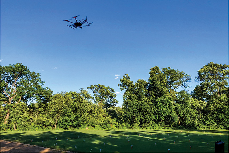
Drone that carries a multispectral camera to capture images of turf surfaces to quantify turf quality and physiological conditions. Photos by Bingru Huang
Water availability for irrigation is declining due to limited freshwater supplies and shifting weather patterns, putting mounting pressure on golf course management. Traditionally, superintendents have relied on four main methods to guide irrigation on fairways: timer-controlled systems that run on fixed time duration and schedules regardless of the weather; weather-station estimates that monitor water loss through evaporation; soil moisture monitoring water status; and field experience, observation and intuition, often referring to as the traditional “look, feel and step” method.
While soil sensors can save significant amounts of water compared to basic timers, they are difficult to scale up effectively across an entire golf course fairway. While relying purely on experience builds an intimate, hands-on connection with the golf course, it also comes with distinct challenges. It relies heavily on constant scouting, and because visual symptoms often appear after the plant has already experienced mild drought stress, it can occasionally lead to a reactive cycle rather than a proactive one. However, even as technology evolves, an experienced superintendent's physical inspection remains the ultimate final check — ensuring that data on a screen matches the actual conditions on the ground. More importantly, none of these traditional indicators capture the true, dynamic water requirements of plants, which vary constantly based on localized soil conditions, microclimates, turf density and current growth stages.
Using remote sensing imagery to evaluate irrigation needs
To address these challenges, modern turf research has focused on high-throughput aerial monitoring. Unmanned aerial vehicles (drones) equipped with specialized multispectral, hyperspectral and RGB cameras can rapidly scan large areas of the golf course to make smart decisions on irrigation needs based on turf performance and soil water content.
Instead of manual, labor-intensive soil checks, these cameras capture how turf reflects different types of light. These cameras capture reflected light across visible and invisible spectrums — such as the red, red-edge and near-infrared bands. By processing this light reflectance data into normalized vegetation indices (VIs), the technology can mathematically quantify canopy density, color, water content and stress responses. Several studies confirm strong relationships between individual VIs (such as NDVI, NDRE, SIPI, PSRI and water band indices) and turfgrass drought responses and physiological performance across species like tall fescue, creeping bentgrass, bermudagrass and Kentucky bluegrass (3, 4, 5, 7, 9). Different VIs capture specific physiological and structural characteristics of the turf canopy. For example, NDVI (Normalized Difference Vegetation Index) measures overall greenness, biomass and turf density. It is a reliable indicator of canopy cover and overall turf vigor; NDRE (Normalized Difference Red Edge) focuses on the red-edge spectrum, providing deep insight into chlorophyll content and early stress detection before visible discoloration occurs; WBI (Water Band Index) evaluates canopy water absorption, making it highly sensitive to changes in plant water content and moisture stress.
Integrating machine learning and multispectral drone imagery to evaluate turf quality and soil water content under deficit irrigation
While aerial imaging provides valuable data, traditional analysis methods, like simple linear equations or basic statistical regressions, fall short. They are prone to errors from outliers, struggle with over-fitting and fail to capture the complex, non-linear relationships between plant physiology and light reflection. Previous studies mostly used linear regression to establish the relationship and correlation of individual VI with turf quality (2, 6) or soil water content (SWC) (1).
With an advanced data analysis tool, employing machine-learning models (ML) can process multiple data variables simultaneously and can integrate multiple VIs derived from the remote-sensing images: 1) tree-based algorithms: Methods like Random Forest, XGBoost and Light Gradient Boosting Machine build sequential decision trees to minimize prediction errors, handling complex data interactions efficiently. 2) neural networks: Multi-Layer Perceptrons mimic artificial neural networks using input, hidden and output layers to model intricate, non-linear patterns in plant stress. 3) support vector regression: These ML models find optimal data margins and are frequently combined with other algorithms to improve overall prediction accuracy and robustness.
Our recent studies focused on integrating these advanced ML algorithms with drone-captured imagery, weather data and variable soil water conditions in a linear gradient irrigation system. Our study aimed to develop predictive ML models integrating multiple UAV-derived multispectral VIs to evaluate turf quality and soil water content for creeping bentgrass fairways under deficit irrigation in a linear gradient irrigation system (LGIS) (8).
The experiment was conducted during two summer periods: July 13 to Aug. 14, 2023, and June 11 to June 28, 2024, at Rutgers University turfgrass research farm. Turf was mowed at 0.375 inches (0.95 centimeters) at least two times each week. Other management practices including fertilization and pest controls following the typical programs on golf courses in the Northeast region. LGIS was used to create variable deficit irrigation and drought stress levels over a 1,000-foot (305-meter) length of a field plot. LGIS sprinklers operated every two days to establish a gradient of soil water content varying by distance from the sprinkler heads. Catch cans were positioned every 20 feet (6 meters) along the 1,000-foot length and every 10 feet (3 meters) across the 59-foot (18-meter) width to calibrate the varying irrigation distribution along the length of the LGIS site.
Following a 10-minute sprinkler run, water collected in the cans was measured with a graduated cylinder, using five catch cans across the width as replicates for each irrigation level. Water amounts collected in each block were converted into a percentage of the daily evapotranspiration (ET) rate, calculated using weather station data (air temperature, humidity and precipitation) from near the experimental field. The irrigation quantity ranged at 80-100% of daily ET rate within the first 20 feet from the irrigation head, 70-80% at 20-40 feet (6-12 meters), 50-60% at 40-59 feet (12-18 meters), 30-40% at 59-78.74 feet (18-24 meters) and 0% at 78.74-98.42 feet (24-30 meters). SWC was measured using a 4.72-inch (12 centimeter) time-domain reflectometer (TDR) probe inserted into the soil to determine the soil water gradient along the LGIS. SWC ranged from 15% (severe water deficit) to 44% (well-watered, field capacity).
Ground and remote-sensing measurements were conducted twice per week (weather permitting) to access turf performance and physiological health during the trial periods. Visual turf quality (TQ) was assessed visually on a 1-to-9 scale (1 being completely dead, 9 being best) based on color, density and uniformity under drought conditions. Remote-sensing data was gathered using a drone carrying a multispectral camera system with 10 spectral bands that captured canopy reflectance to calculate VIs, using a reflectance correction panel to adjust for varying light conditions during post-processing. Flights took place within 1 hour of solar noon at an altitude of 82 feet (25 meters,) a speed of 13 feet (4 meters) per second and 75% front and side overlap.
In our study, ML models that integrated multiple VIs significantly outperformed traditional linear regression when using individual VI to monitor turf quality or soil moisture content. We measured this using the coefficient of determination (R2, where values closer to 1 indicate higher predictive accuracy), a statistical measure that shows how well a model predicts real-world data. However, not all computer algorithms perform the same. The best model depends heavily on what you are trying to measure: For evaluating and predicting turf quality, the Multi-Layer Perceptron (MLP) model performed best (R2 = 0.85). Its neural network design handles the complex, overlapping factors that influence overall turf health. For monitoring and predicting soil water content, the LightGBM (LGBM) model performed best (R2 = 0.81). Tree-based models are better suited for physical soil data, seamlessly handling thresholds like soil field capacity (around 44% moisture) and vegetation index saturation.
These findings suggest that machine-learning algorithm selection for the analysis of remote sensing data is critical for predictive modeling in turf and soil management and ensure superintendents can rely on precise data to make smarter irrigation decisions on fairways. While these ML models successfully capture complex non-linear relationships to assist with drought-tolerant cultivar breeding and efficient irrigation, future work must address limitations regarding data quality and quantity, model interpretability, cross-species validation and real-world scalability.
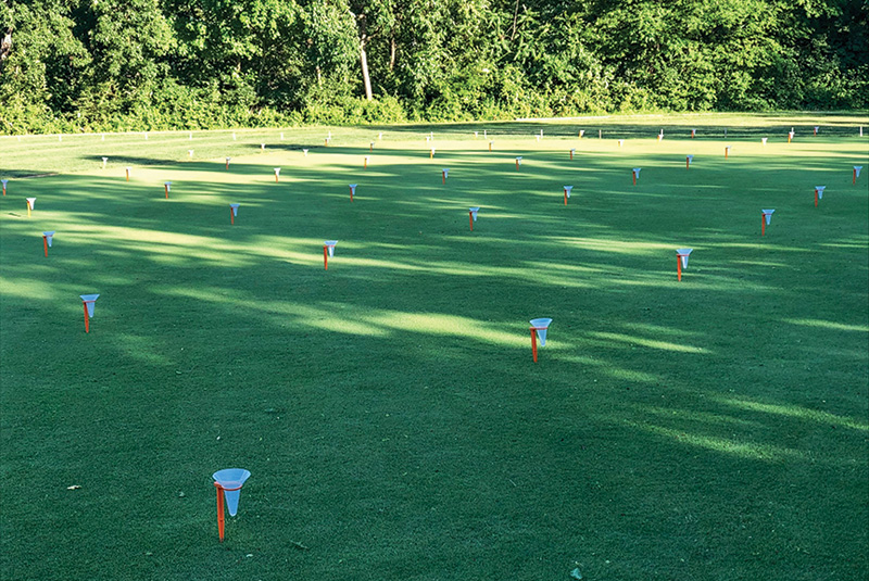
Catch cans used to calibrate different irrigation water quantity in the test field plot along the linear gradient irrigation system (LGIS).
Conclusions
Integrating remote sensing data and machine-learning models for monitoring and predicting turfgrass drought responses holds remarkable potential for optimizing water conservation through targeted irrigation management and high-throughput phenotyping of drought-tolerant turfgrass. By combining aerial data with smart predictive models, turf managers can accurately predict both soil water content and turf quality under deficit irrigation, paving the way for advanced and efficient precision irrigation programs. Although further work remains necessary to validate and fine-tune these systems across diverse turfgrass species and varying management conditions — as well as scale the models to real-world field environments to confirm broader universality and predictive reliability — this approach ultimately offers an exciting pathway toward smarter, more sustainable turfgrass management.
The research says
- Integrating remote sensing data and machine-learning models for monitoring and predicting turfgrass drought responses holds remarkable potential for optimizing water conservation through targeted irrigation management and high-throughput phenotyping of drought-tolerant turfgrass.
- By combining aerial data with smart predictive models, turf managers can accurately predict both soil water content and turf quality under deficit irrigation, paving the way for advanced and efficient precision irrigation programs.
- Further work remains necessary to validate and fine-tune these systems across diverse turfgrass species and varying management conditions — as well as scale the models to real-world field environments to confirm broader universality and predictive reliability.
- This approach ultimately offers an exciting pathway toward smarter, more sustainable turfgrass management.
Literature cited
- Dettman‐Kruse, J.K., N.E. Christians and M.H. Chaplin. 2008. Predicting soil water content through remote sensing of vegetative characteristics in a turfgrass system. Crop Science 48(2), 763-770 (https://doi.org/10.2135/cropsci2006.01.0040).
- Fitz-Rodríguez, E., and C.Y. Choi. 2002. Monitoring turfgrass quality using multispectral radiometry. Transactions of the ASAE, 45(3), 865-871.
- Guillard, K., and J.C. Inguagiato. 2017. Normalized Difference Vegetative Index Response of Nonirrigated Kentucky Bluegrass and Tall Fescue Lawn Turf Receiving Seaweed Extracts. HortScience 52(11), 1615-1620 (https://doi.org/10.21273/HORTSCI12090-17).
- Katuwal, K.B., H. Yang and B. Huang. 2023. Evaluation of phenotypic and photosynthetic indices to detect water stress in perennial grass species using hyperspectral, multispectral and chlorophyll fluorescence imaging. Grass Research 3(1) (https://www.maxapress.com/article/doi/10.48130/GR-2023-0016).
- McCall, D.S., X. Zhang, D.G. Sullivan, S.D. Askew and E.H. Ervin. 2017. Enhanced soil moisture assessment using narrowband reflectance vegetation indices in creeping bentgrass. Crop Science 57(S1), S-161 (https://doi.org/10.2135/cropsci2016.06.0471).
- Mutlu, S.S., N.K. Sönmez, M. Çoşlu, H.R. Türkkan and D. Zorlu. 2023. UAV-based imaging for selection of turfgrass drought resistant cultivars in breeding trials. Euphytica 219(8), 83 (https://link.springer.com/article/10.1007/s10681-023-03211-3).
- Roberson, T.L., M.J. Badzmierowski, R.D. Stewart, E.H. Ervin, S.D. Askew and D.S. McCall. 2021. Improving soil moisture assessment of turfgrass systems utilizing field radiometry. Agronomy 11(10), 1960 (https://doi.org/10.3390/agronomy11101960).
- Yang, H., D. Gladden, S. Rossi and B. Huang. 2026. Remote sensing and machine learning models to assess and predict turfgrass performance and soil water stress under deficit irrigation for creeping bentgrass. Crop Science 66(2) e70265 (https://doi.org/10.1002/csc2.70265).
- Yousfi, S., R.J. Marín, L. Parra, J. Lloret Mauri and P.V. Mauri. 2022. Remote sensing devices as key methods in the advanced turfgrass phenotyping under different water regimes. Agricultural Water Management 266, 107581 (https://doi.org/10.1016/j.agwat.2022.107581).
Acknowledgements
Funding support from USDA-NIFA (GRANT13369223, Award No. 021-51181-35855-SCRI) and Rutgers Center for Turfgrass Science.
This article was written based on the following publication
Yang, H., D. Gladden, S. Rossi and B. Huang. 2026. Remote sensing and machine learning models to assess and predict turfgrass performance and soil water stress under deficit irrigation for creeping bentgrass. Crop Science 66(2) e70265 (https://doi.org/10.1002/csc2.70265).
Bingru Huang, Ph.D., (huang@sebs.rutgers.edu) is a Distinguished Professor and Haoguang Yang is a Ph.D. student, both in the Department of Plant Biology, Rutgers University, New Brunswick, N.J.